
Category - GCP,Ground Control Points
Posted - 05/30/2017 11:01am Ground Control Points (GCPs)
What Are Ground Control Points?
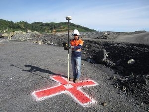
Ground Control Points, or GCPs, are marked points on the ground that have a known geographic location. In aerial surveying, a drone can be used to autonomously collect photos of the survey area. If used, GCPs must be visible in these aerial photos. The photos are then processed in the cloud using drone mapping software. A common solution for collecting and processing drone data, used by many mapping professionals, is DroneDeploy. Services like DroneDeploy create 2D orthomosaics, 3D models, digital elevation models (DEMs), and 3D point clouds from drone images. For aerial survey applications GCPs, are typically required as they can enhance the positioning and accuracy of the mapping outputs. To do this correctly, the GCPs and desired mapping outputs must use the same ESPG code.
When Do You Need GCPs?
YOU DON'T NEED GCPS
You do not need GCPs if only relative accuracy is important. Drone mapping projects that only require high relative accuracy include:
- Measuring length, area, and volume of objects

- Construction Site Management and Oversight

- Crop Scouting

- Creating Marketing Material

YOU DO NEED GCPS
If absolute accuracy is important then you will need use GCPs on your map. Drone mapping projects that require high absolute accuracy include:
- 
Land Title Surveys

- As-Built Surveys

- Environmental Documentation

- Overlaying Geo-Referenced Site Plans
Read More
https://www.groundcontrolpoints.com

- All
- Agriculture
- Altitude
- California
- Commercial
- Construction
- Crop Science
- Drone Guns
- FAA
- GCP
- General
- Ground Control Points
- Industrial
- Instruction
- Insurance
- Legal
- Light
- Mapping
- NDVI
- Photogrammetry
- Photography
- Public Concern
- Regulations
- Reviews
- Safety
- Security
- State PArks
- Stitching
- Terrain Mapping
- Vineyards
- Volume Measurement
- Webinars
- Wildfires
- Wine Country
- Nov 2018
- Jun 2018
- Mar 2018
- Jan 2018
- Oct 2017
- Aug 2017
- Jul 2017
- Jun 2017
- May 2017
- Mar 2017
- Feb 2017
- First Passenger Drone Set to launch in July
- A drone software firm has hired two execs from Salesforce and NetSuite
- Drones For Farmers Makes Midwest Startup A Flying Success
- 5 things I learned taking photos with the DJI Phantom 4 Pro
- Drone Captures Wildfire Devastation in Chile
- Caterpillar invests in Airware bringing drone tech to mining and construction enterprises
- FAA: Keep your drone far, far away from the Super Bowl
- Jan 2017
- Man slapped with misdemeanor citation for flying drone near cliffside rescue in Pacifica
- Ningaloo Reef captured from sky in drone-driven health check
- Antonio's One Shot Review, Phontom 4
- What can NDVI drones do for my business? Part 1
- Falcons, drones, data: A winery battles climate change
- senseFly to Host Free ‘Ag Drone Insights’ Webinar
- Modern warfare: Death-dealing drones and ... illegal parking?
- Using a drone during the inauguration could get you fined $1,414
- North Royalton considering banning drones from public areas
- US regulators hammer down on unauthorized drone use
- In Davos, the Police Will Disarm Your Drone in a Heartbeat
- Drone's operator detained for flying near Chinese airplane
- Illegal Drone FPV Transmitters Could Interfere with Air Traffic Control
- Fields of Gold
- Drone delivers medical response