THE CSIRO has this month gone into partnership with Australia's largest rural services and advisory company Ruralco to fund drone productivity studies.
"Drone technology is facilitating data-driven decision-making in agriculture; it can help farmers better analyse issues which affect productivity and sustainability," says Ruralco chief executive Travis Dillon.
"This is about us staying ahead of the innovation curve; we don't know exactly where the next productivity leaps in agriculture will come, but technology and data will certainly be at their heart."
Perhaps they will unlock the secret to make drone technology a true return on investment proposition, but in the meantime drones are like golf training aids. We think we should have them but we're not quite sure if they have any significant benefit.
That's the message from farmers who have been contributing to the boom in drone sales that is expected to see global revenues soar to $15 billion in 2021.
The vast majority of those sales are in hobby or consumer drones which are capable of covering a kilometre or two with limited camera functionality.
They're not very expensive and from a budget conscious farmer's perspective, they have a use in keeping an eye on things such as fences and livestock.
But one Australian drone importer says those cheap hobby drones are next to useless in farm applications.
Under stress: Birchip Cropping Group has been trialling a fixed-wing drone — a SenseFly eBee. BCG research officer Sebastian Ie with the drone.
"The limiting factor for an off-the-shelf drone is range it can fly and time in the sky," says Bob Guegan from Just Drones.
"They simply don't have the range required by most farmers we have spoken to, and other than DJI drones, their cameras aren't good enough for any serious agricultural work."
He says DJI has become the "iPhone of drones" with models that work well for farmers, offering lengthy flight time and range, as well as a decent camera to capture video and still imagery.
Mark Playdon from Drone Addiction agrees.
"DJI is leading the pack globally with several types ranging from the tiny Spark to the large matrice," he says.
"For just general keeping an eye on things, DJI Mavic could be suitable, as well as the Phantom 4 series.
"These are all under 2kg and so can be used commercially without a licence."
Western Australian broadacre farmer and agronomist Leigh Nairn has been using a DJI Phantom 4 Pro to scout trial paddocks and monitor emergence.
He was monitoring his seeder setup, which was having issues lining up with the GPS, when an eagle attacked the drone — one of the hazards of flying them.
He got a fantastic image from the attack and the repair bill wasn't significant, and he continues to carry it around as an everyday tool.
"You can carry it around in a camera bag with the arms folded in, take it anywhere and throw it up wherever you want to get some good pics," he says.
He also has a larger DJI Matrice model which is fitted with near infrared cameras that detect stressed crop or weeds and help create normalised digital vegetation index (NDVI) maps using third party software.
"We are using that for bio imagery and NDVI maps and putting that into DroneDeploy or PrecisionHawk which are programs that process the data from the drone," he says.
While something like a DJI Phantom 4 will cost around $2000, these more professional drones are getting into five figures.
Australian company Falcon UAV custom makes a drone called the AgFalcon which has six rotors, a full near infrared set up with batteries, chargers, spare parts and the near infra-red camera along with all the software as a total package for $12,000.
Falcon UAV's Phil Lyons extols the benefits of drone NDVI mapping and says when they're done properly, they can lead to efficiencies such as savings in chemicals.
"Obtaining a drone-produced NDVI map as soon as enough leaf matter is showing can lead a grower to those areas of low near-infrared reflectance, indicting some stress problem," he says.
"In some cases, we have seen a bug infestation that the grower did not know existed due to the size of his paddock, which would have led to massive crop losses."
Leigh Nairn says he uses his near infrared package 10 per cent of his drone flying time.
"We researched drones a fair bit before investing and I wanted to see if it could do what I wanted, which was take imagery and put that into a nitrogen recommendation for a sprayer," he says.
"That technology is not quite there yet."
.
He's not the only one to say that. NDVI mapping is great when it's accurate and the only way to ensure that is to visit the suspect areas on foot — ground truthing.
Cheaper satellite imagery can provide an NDVI map as well although a drone can achieve much higher resolution. But with the necessity to ground truth, the investment in an expensive drone makes less sense.
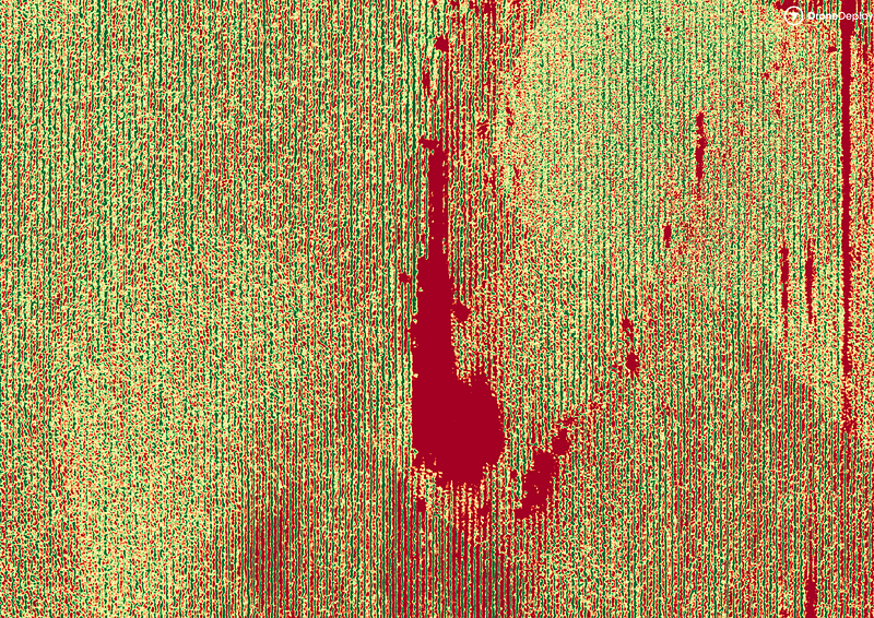
Birchip Cropping Group researcher Sebastian Ie has been creating NDVI maps with a $40,000 fixed-wing drone.
"That map will show you greenness but it won't differentiate between weeds and crop, so you have to ground truth," he says.
"Is there a cheaper way? The alternative is free satellite NDVI data which would give you a general idea of what's going on.
"From our perspective a drone has a high enough resolution that you could pick up data from all of our trial plots, which is something you couldn't get from satellite data.
"The value of higher resolution mapping is not so clear for the farmer and is not something that has been proven yet."
Mr Nairn says he doesn't think it will be too long before farmers would see a return on investment in NDVI mapping as the technology improves.
"What I'd eventually like to see is drones locating weeds and then a ground robot drives out there to spray it," he says.
In the short term, he says even improving the ability to identify weeds to create prescription maps to enable spot spraying would be a huge step forward.
But one thing everyone agrees on is that drones are here to stay.
Sensors on fields and crops are starting to provide literally granular data points on soil conditions, as well as detailed info on wind, fertilizer requirements, water availability and pest infestations. GPS units on tractors, combines and trucks can help determine optimal usage of heavy equipment. Data analytics can help prevent spoilage by moving products faster and more efficiently. Unmanned aerial vehicles, or drones, can patrol fields and alert farmers to crop ripeness or potential problems. RFID-based traceability systems can provide a constant data stream on farm products as they move through the supply chain, from the farm to the compost or recycle bin. Individual plants can be monitored for nutrients and growth rates. Analytics looking forward and back assist in determining the best crops to plant, considering both sustainability and profitability. Agricultural technology can also help farmers hedge against losses and even out cash flow.
The software market for these sorts of precision farming tools (such as yield monitoring, field mapping, crop scouting and weather forecasting) is expected to grow 14% by 2022 in the United States alone. Researchers suggest the full-scale adoption of these technologies could mean an increase in farm productivity unseen since mechanization.
There was a time when the idea of spraying insecticide and fertilizer
on crops from the air seemed farfetched. Today airplanes do exactly
that. Now the agricultural industry is considering another type of
airborne vehicle — drones.
More farmers are using the unmanned aircraft systems to maximize the
efficiency of agriculture, increasing crop yields at reduced cost,
effort and impact on the environment.
Drones equipped with specialized cameras wirelessly linked to
location software and mapping tools can survey fields from above to
detect and diagnose crop stresses. Armed with this data, farmers can
take corrective actions.
Precision Drone embeds each vehicle with an
infrared video camera and technology that can detect live vegetation.
Credit: Precision Drone
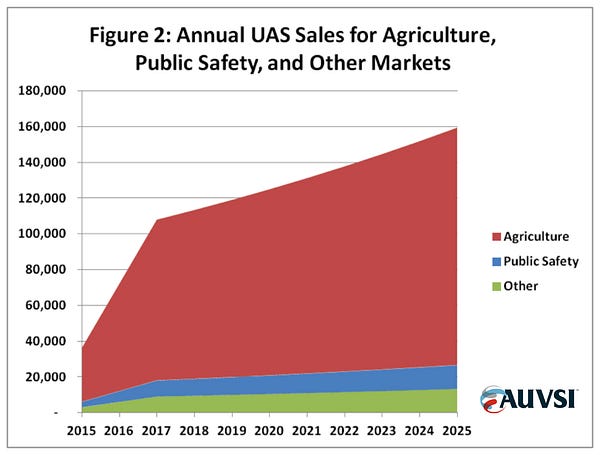
Although the use of drones in farming is in its formative stages, the Association for Unmanned Vehicle Systems International anticipates that farms will eventually account for an 80 percent share of the commercial drone market globally.
Misconceptions and advice from agriculture industry experts
There's a lot of hype about agriculture drones. By AUVSI's own estimates, the U.S. drone industry will be worth $82 billion by 2025, with agriculture generating the lion's share.
Source: auvsi.org/econreport
For
the most part, the hype is warranted — but there's also a decent amount
of confusion surrounding ag drones. Just try some quick Googling and
you'll start noticing trends; everyone is talking about NIR (near
infrared) cameras, vegetation indices, and of course, the ubiquitous NDVI.
We're going to attempt to answer the why, how, and when so that you'll be able to manage your expectations of what NDVI can (and can't) do for you.
Why do I need NDVI, how do I make NDVI maps, and when do I use them?
To answer these questions and give insight, we've assembled four industry experts — a veritable pantheon of ag pros.
Let's
roll up our sleeves and get our hands dirty as we delve into part one
of our two-parter on NDVI, drones, and the agriculture industry.
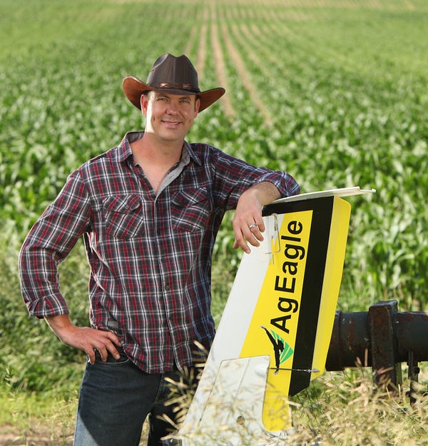
Norm has been previously featured on our blog with the Soybean case study
Norm, a manned aircraft pilot, is one of DroneDeploy's most active mappers. He mainly uses his AgEagle. All of Norm's flights are focused on generating actionable aerial imagery. In his business, Deveron UAS, Norm flies drones as a service for growers and farmers — and business is good.
Farming runs in his blood; besides merely looking the part (he's literally Mr. October in the 2016 Faces of Farming calendar), he also walks the walk.
It is extremely important to put your boots on the ground.
What is NDVI to you?
NDVI
is not a new formula by any means. It's been available to farmers from
satellites as an entry-level aerial perspective for a while. It has been
very easy to get into and produce. I think that's why it's been so
widely used.
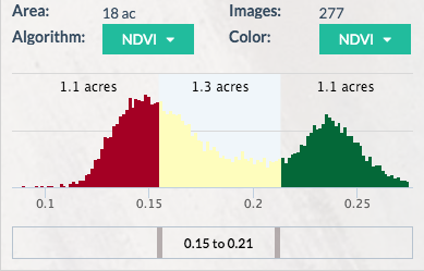
Ag Toolbox: real-time vegetation index analysis
What is the value of NDVI?
Where
we see value is variability. There is always variability in all fields.
NDVI highlights this variability and makes it easier for your eyes to
see. When you can easily see variability, you can make quicker
decisions.
What are some of the challenges with using NDVI?
One
of the challenges with using NDVI is that you're not always dealing
with absolute values. When lighting conditions and cloud cover change,
the camera lens gives you a value of what it sees but doesn't account
for the atmospheric change. If you fly over the same fields on different
days with the same camera, you should get the same values… but you
don't. You'll get the same variability but you won't get the same
numbers on the NDVI scale.
Because of this, it is extremely important to put your boots on the ground — every NDVI map should still be ground-truthed.
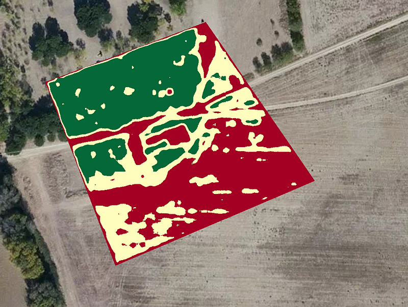
Thresholded NDVI map showing variability
What's your advice to people who are new to using agriculture drones?
People
see a relatively cheap price tag on a drone and think that's all it
takes. I come from the aviation industry. Yeah, $50k can get you a
Cessna, but that's just the starting point. There are hidden costs.
It's
easy not to see the amount of time you spend maintaining the equipment,
all the hours uploading and manipulating the images, putting data in
specific formats, or the regulatory side of things.
In
Canada there are restrictions for operating and permits to obtain. You
have to be compliant and safe to run a legitimate business. Be prepared
for a lot of work, not just in the fields and at the computer but on the
regulatory side as well.
Chad Colby is a complex guy: drone evangelist, public speaker, technology early-adopter, professional snowmobiler.
The son of a farmer and the husband of an agronomist, Chad does it all
and has fun doing it. His garage of toys puts others to shame. But in
Chad's garage, the drones don't classify as toys — they're tools.
The power right now is in understanding your own field. Truly understanding it. Soil type, history — all of it.
What is your experience with NDVI?
NDVI
has been around for a long time. Drones are a bit newer. Just three
years ago we were so focused on putting a drone in the air and getting
this NDVI image. It was all that mattered. Stick a modified GoPro on the
drone, send it on up, and create the best image ever!
After
flying, it took 15-20 hours to process the data. That's what we did
back then. These days it's easier. We want to see the inconsistencies in
our fields.
NDVI imagery processed from a modified camera
What are some misconceptions about NDVI?
I
don't care what NIR camera you're using — it takes no account for the
soil, the fertility, or other problems in the field. It's just basing
the decision off of the vegetation algorithm and imagery from that day.
It's not necessarily the holy grail. NDVI maps do not replace an
agronomist in the field.
Are yield estimations valuable to a grower?
Not
as much as you'd think. Guessing yield is not a critical or unknown
component to a farmer. Growers have known how to do that their whole
lives. They can take a small section of field, make a quick count, and
extrapolate that across the entirety for an accurate estimation.
So what do growers want to know?
They
want to know if they have problems on this 160 acre field today or can
they move on to the next field and continue their daily routine. The
immediacy of the data is what can make a big difference. False NDVI
imagery from RGB cameras can even be valuable if they highlight
inconsistency — it can be a huge time saver to quickly detect variance
and then go to the spot and make a decision.
A DJI Inspire 1 on a mapping mission above a field
Any advice for those who are starting a new drone business?
Lots
of people are asking how to get into ag with drones. Farmers and
growers need to be able to rely on their service provider. You have a
huge advantage if you can be at your client's field immediately during,
or after a weather event.
Solar panels dot the buildings at Jackson Family Wines' Carneros Hills
Winery in Carneros, Calif. Jackson Family Wines is among winemakers
employing both high-tech and old-school techniques to adapt to hotter,
drier conditions, including using drones to monitor crops and falcons to
scare away grape-eating birds.
On a misty autumn morning in Sonoma County, Katie Jackson
headed into the vineyards to assess the harvest. It was late in the
season, and an army of field workers was rushing to pick the grapes
before the first rains, however faint, began falling.
But
on this day, Jackson, the vice president for sustainability and
external affairs at Jackson Family Wines, was not just minding the usual
haul of cabernet, chardonnay and merlot grapes. She also checked on the
sophisticated network of systems she had put in place to help crops
adapt to a changing climate.
Jackson, along with her
siblings and mother, owns and operates Jackson Family Wines, one of the
largest family-owned winemakers in the country. Best known for its
Kendall-Jackson chardonnay, a supermarket staple, the family also
produces dozens of other wines on five continents. After decades in the
business, the Jacksons are sensitive to slight variations in the
weather, and they are convinced of one thing: It is getting hotter and
drier, and that could be a problem.
As
California endures a years-long drought, the Jacksons, like other
winemakers, are grappling with new realities. Grapes, though a
surprisingly resilient crop, are ripening earlier. Nights are warmer.
Aquifers are running dry.
As a result, the region's wine
country has become a laboratory for the reshaping of agriculture
nationwide. Because, of course, it's not just California that's warming
up.
The growers are going have to be a little bit more nimble.
senseFly,
the world’s first choice producer of professional mapping drones, will
host a free educational webinar focusing on the different applications
of drones in agriculture at 10:00 EST/16:00 CET on Tuesday, January 24.
During this event, experienced operators from two of the ag market’s
agronomy leaders—AIRINOV (France) and Deveron UAS (Canada)—will discuss
their companies’ drone use, including the opportunities and challenges
that adopting this technology brings. Attendees must register in advance
here for the one-hour webinar, entitled Ag Drone Insights – Experienced Agronomists Discuss UAV Results, Costs, Workflows and More.
“Across the globe, agronomists, growers and researchers are
increasingly using drones to gain deeper insights and to optimise their
operations,†said senseFly’s CEO, Jean-Christophe Zufferey. “This
webinar will help professionals who have yet to adopt UAV technology to
more fully understand how and when drones can help drive their
businesses, and those of their clients, forward.â€