
Category - General
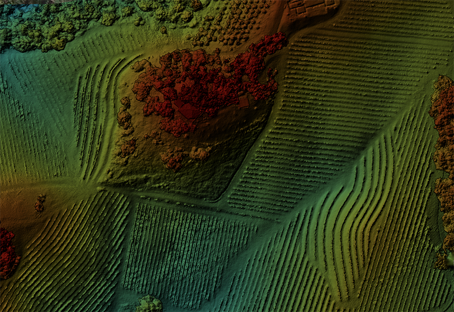
Posted - 11/12/2018 10:39pm Simulated NDVI (VARI), is there anything to be gleaned from it?
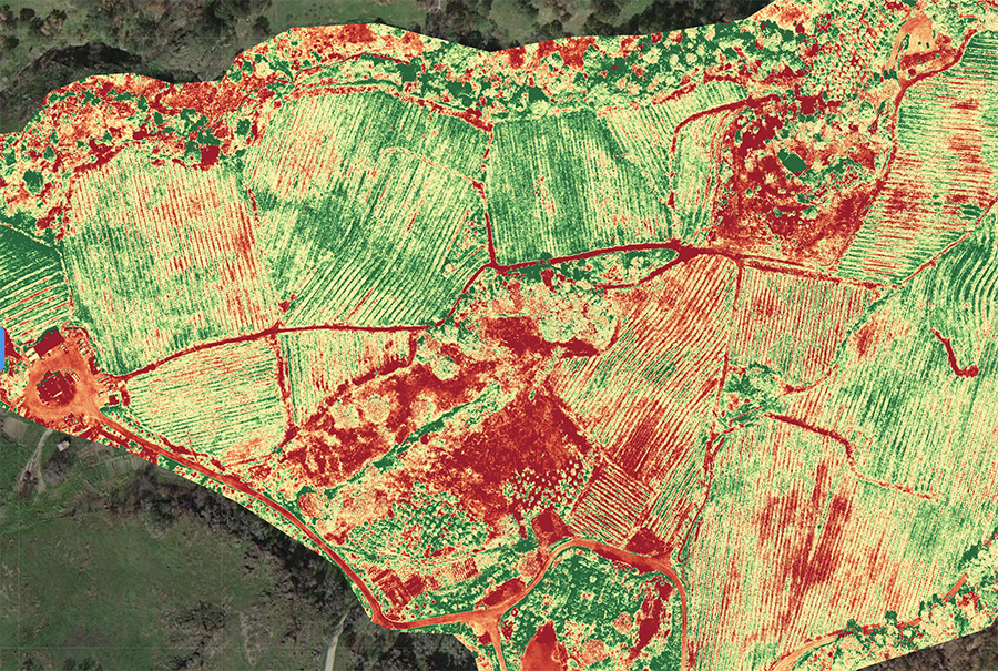
Last year I had the opportunity to study a 200 acre mountain vineyard property throughout the 2017 growing season. We made our first maps in March of 2017, and the final maps on November 1st, 2017. During the course of the season we flew the property 13 full days, each "day" averaging 10 - 14 individual flights. It was a great experience, enough for a book and far too much for a blog, but one of the interesting take-aways to me was simulated NDVI (VARI) and elevation studies.
Normalized Difference Vegetation Index (NDVI) *@wikipedia
Visible Atmospherically Resistant Index (VARI) *@dronedeploy
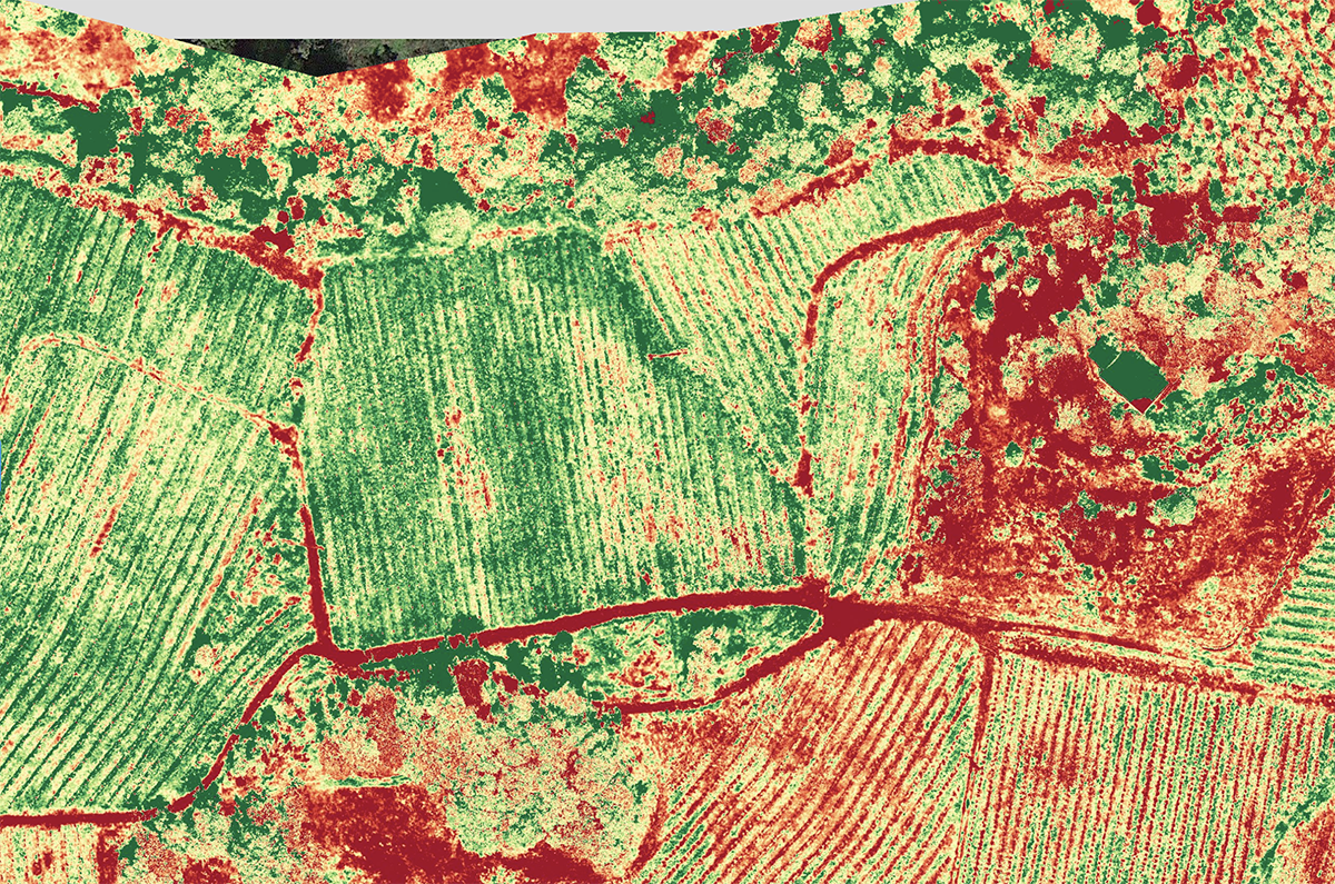
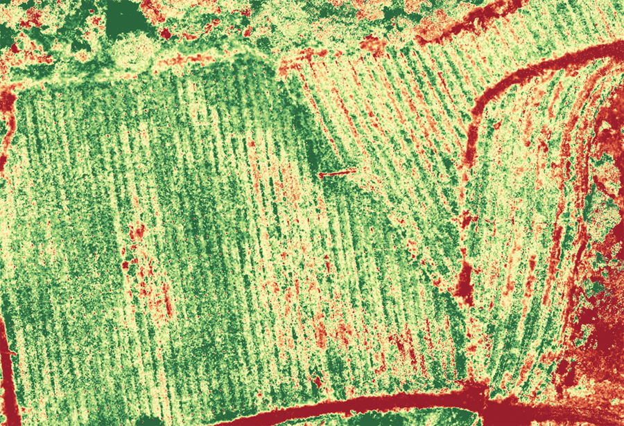
Do I see anything at all? Are there areas of color that are growing better than other areas of color, if so, why? Is there anything we can do to move one from one side to the other?
Again I don't know, I'm not a wine maker or a farmer or a ranch hand...or a crop scientist, I'm just a guy looking at images and wondering if they make a difference.
Category - General
Posted - 06/15/2018 12:45pm Latest Sonoma Drone Promotional Video
Category - General
Posted - 01/19/2018 02:42pm Know the Rules before you Fly!
In the past month alone I had had people tell me these very frightening (and incorrect) "facts":
- You can fly drones at night, as long as you have lights.
- You can fly FPV (first person view, i.e., using VR goggles) without an observer.
- As long as you can see what the drone sees (through the camera), you can fly it as far away as you want.
- Drones have to fly under 400' and planes have to fly over 500' so drones and planes never share the same airspace. (perhaps the most frightening of them all)
- You can fly 400' over the highest point around you (oh boy...)
- I don't need to be certified if I am just selling the images & video I take
While none of those statements above hold any truth, here are real answers to some of the most common questions:
Who needs to be certified?
Anyone operating any sUAS for hire. Under Part 107, every commercial drone operator needs to be certified by the FAA before they fly over a job site, mine, farm, or any other commercial property. If you are flying your Drone for hire or even for your own in-house commercial use, you must be certified.Do you need to Register Your Aircraft?
Every aircraft weighing between .55 lbs (250 grams) and 55 lbs (25 kg) needs to be registered with the FAA.How far away can you fly?
If you can't see it, it's not legal. You must, or you must have a visual observer in direct communication with you who can maintain a visual line of sight at all times. Any time you fly commercially, you have to keep the UAV within visual line of sight (VLOS). If using First Person View (FPV) or other similar technology, you must also have a visual observer on site to keep an eye on the vehicle without the use of a visual aid (like binoculars).When can you fly?
You are able to fly during daylight or twilight hours (30 minutes before official sunrise to 30 minutes after official sunset, local time) with appropriate anti-collision lighting.What about Weather?
Minimum weather visibility is three miles from your control station.How High can you fly?
The maximum allowable altitude for any drone is 400 feet above ground level (AGL). There are exceptions if your drone remains within 400 feet of a building (or structure) the pilot in command is operating from. The maximum speed is 100 mph (87 knots).Steer Clear of People
You can't fly a small UAS over anyone who is not directly participating in the operation at the time. You also can't fly the aircraft from under a covered structure, nor from inside a covered stationary vehicle.Category - General
Posted - 05/28/2017 08:19pm A Year in the Life of a Vine

Spring
The grape starts its annual growth cycle in the spring with bud break. Tiny buds on the vine start to swell and eventually shoots begin to grow from the buds. Buds are the small part of the vine that rest between the vine's stem and the leaf stem. Depending on temperatures, 40–80 days after bud break the process of flowering begins with small flower clusters appearing on the tips of the young shoots. The stage of fruit set follows flowering almost immediately, when the fertilized flower begins to develop a seed and grape berry to protect the seed.
Read the whole post here:
Category - General
Posted - 03/03/2017 04:44pm Geo Fencing
Kaveh Waddell
Some drones are programmed to avoid restricted airspace—but it’s not hard to ignore the limits and fly there anyway.
A drone flying through the air in southwest Baltimore might, if it wanders too far in the wrong direction, stop suddenly in midair, as if running into an invisible force field. The obstacle isn’t physical—it’s been programmed into the software that helps the drone fly. A ring with a 30-nautical mile radius centered on the Ronald Reagan National Airport, delineates the D.C. Special Flight Rules Area, where drones aren’t allowed—and so many consumer drones obediently stay away.
Technology that keeps drones from entering restricted airspace is called geofencing. It’s a straightforward system: Drones that support geofencing regularly download databases from their manufacturers that delineate active no-go zones. If a drone flies toward a restricted area, its built-in GPS will sense the boundary, and the drone will stop mid-flight; if an operator tries to take off inside a restricted area, the drone won’t start up at all.
Most restricted areas are permanent. An area five miles in radius around airports, for example, is always off-limits to drone enthusiasts, without prior approval from the airport’s control tower. But the Federal Aviation Administration also announces temporary flight restrictions, or TFRs, to protect big public events like the Super Bowl, guide pilots away from hazards like wildfires or pipeline explosions, or shield the president when he travels.
Information about temporary restrictions bounces along a winding path on its way to many of the hundreds of thousands of drones in the United States. Here, for example, is how information about President Trump’s upcoming visit to Mar-a-Lago, his club in Palm Beach, Florida, will end up being disseminated to consumer drones.
The process for establishing a presidential TFR begins when the Secret Service reaches out to the FAA and requests that a protective zone be set up wherever the president is headed. The FAA then publishes a Notice to Airmen, or NOTAM, with details about the restriction. Every time a pilot is getting ready to start their engines—whether they’re flying a business jet, prop plane, or three-pound drone they got for Christmas—they are supposed to check for new NOTAMs to make sure their flight path doesn’t cross restricted airspace.
The FAA has a clunky website where pilots can browse current and scheduled NOTAMs, but there are easier ways to access that data, too. The agency has a free, simple smartphone app called called B4UFLY that uses the phone’s GPS to show nearby restrictions—and it shares that data with a few other companies as well.
One of them, AirMap, gets data about travel restrictions from the FAA every few minutes, a spokesperson for the company said. In addition to plotting them on an interactive map, the company makes the data available to drone companies that subscribe to its service—including DJI, the largest manufacturer of consumer drones.
DJI, in turn, classifies the data in three categories: warning zones, authorization zones, and restricted zones. Finally, those areas, with their classifications, are sent to every internet-connected DJI drone that supports geofencing.
Warning zones tell drone operators they’re flying over a special area, but don’t prevent flight there—a protected wildlife area might be categorized this way.
Most temporary flight restrictions are designated as authorization zones, which require drone operators to confirm their intention to fly in. When a drone noses up against one of these, its operator will be asked to “self-authorize,†acknowledging the fact that there might be extra rules in the area the drone is entering. “By doing that, you say in the popup window that you have authorized business in here,†said Adam Lisberg, a spokesperson for DJI. (The 30-mile zone around D.C., for example, is an authorization zone.)
To self-authorize, operators need to have connected their drone to their identity by submitting a mobile phone number or a credit-card number. That way, if law enforcement has questions about a DJI drone flying where it shouldn’t be, the company can help police track down its operator. Lisberg says the company complies with all legitimate law enforcement requests, but wouldn’t share any details about how often such requests come in.
Restricted zones come with the most limitations. Those areas, which protect sensitive locations like airport runways or nuclear power plants, are inaccessible to DJI drones, and aren’t eligible to be unlocked by authorized users. Within the 30-mile authorization zone surrounding D.C., a smaller 15-mile area is classified as restricted. (Since drones are sometimes used to inspect sensitive infrastructure like airports and power plants, DJI makes case-by-case exceptions as needed.)
This weekend, the FAA will activate a flying restriction that’s 60 nautical miles in diameter around Palm Beach, to coincide with Trump’s visit. The agency has a standing protocol for protecting Mar-a-Lago, since it’s a usual haunt for the president.
But although presidential TFRs are designed to protect the leader of the free world from aerial attacks, they aren’t categorized as a restricted zone in DJI’s system. Like any other TFR, such as one established over a wildfire, it’s designated as an authorization zone. That means a verified DJI drone operator who’s willing to take a risk could self-authorize and fly their drone near the president this weekend, if he or she wanted to.
A spokesperson for the FAA says that there shouldn’t be any difference between TFRs for drone operators. “If you’re not allowed to fly there, you’re not allowed to fly there,†the spokesperson said.
DJI’s system is solely educational, Lisberg said; it’s not designed to enforce air-traffic laws or punish bad actors. “That’s not our job any more than a car manufacturer is responsible for making sure people adhere to the speed limit.†It remains the responsibility of each drone operator to make sure they’re not flying someplace they shouldn’t.
Several other drone manufacturers use the FAA’s or AirMap’s data for flight awareness, too, including Intel, Aeryon Labs, 3D Robotics, Yuneec, and senseFly, the commercial arm of a popular French drone maker called Parrot. (A Parrot representative said the company’s consumer drones don’t have automatic geofencing technology, and that its commercial drones only use AirMap data for flight planning.)
Ultimately, no matter how detailed the data is that AirMap feeds to drone manufacturers, the final authority on temporary flight restrictions is the FAA. If a drone operator really wants to circumvent restrictions built into his or her drone, there’s little in the way of liftoff, except for the legal consequences the government might impose if the drone is discovered in the air: The FAA says individuals can be fined more than $1,400 for violating TFRs.
Category - General
Posted - 02/13/2017 04:59pm First Passenger Drone Set to launch in July
The arrival of the Chinese-made EHang 184 — which already has had its flying debut over Dubai's iconic, sail-shaped Burj al-Arab skyscraper hotel — comes as the Emirati city also has partnered with other cutting-edge technology companies, including Hyperloop One.
The question is whether the egg-shaped, four-legged craft will really take off as a transportation alternative in this car-clogged city already home to the world's longest driverless metro line.
Mattar al-Tayer, the head of Dubai's Roads & Transportation Agency, announced plans to have the craft regularly flying at the World Government Summit. Before his remarks on Monday, most treated the four-legged, eight-propeller craft as just another curiosity at an event that views itself as a desert Davos.
"This is not only a model," al-Tayer said. "We have actually experimented with this vehicle flying in Dubai's skies."
The craft can carry a passenger weighing up to 100 kilograms (220 pounds) and a small suitcase. After buckling into its race-car-style seat, the craft's sole passenger selects a destination on a touch-screen pad in front of the seat and the drone flies there automatically.
The drone, which has a battery allowing for a half-hour flight time and a range of up to 50 kilometers (31 miles), will be monitored remotely by a control room on the ground. It has a top speed of 160 kph (100 mph), but authorities say it will be operated typically at 100 kph (62 mph).
Al-Tayer said the drone would begin regular operations in July. He did not elaborate.
The Road and Transportation Agency later issued a statement saying the drone had been examined by the Dubai Civil Aviation Authority and was controlled through 4G mobile internet. The agency did not immediately respond to further questions from The Associated Press.
The United Arab Emirates already requires drone hobbyists to register their aircraft. However, drone intrusions at Dubai International Airport, the world's busiest for international travel, has seen it shut down for hours at a time in recent months.
EHang did not respond to a request for comment. In May, authorities in Nevada announced they would partner with EHang to test the 184 to possibly be cleared by the U.S. Federal Aviation Administration.
The drone may be a techno curiosity for now but Dubai — the commercial capital of the oil-rich UAE and home to the long-haul carrier Emirates — has bold visions for the future and the 184 fits right into its plans.
Dubai's ruler, Sheikh Mohammed bin Rashid Al Maktoum, announced in April he wanted 25 percent of all passenger trips in the city to be done by driverless vehicles in 2030. To that end, Dubai already has had the box-shaped driverless EZ10, built by France's EasyMile, cruise nearby the Burj Khalifa, the world's tallest building.
In October, Dubai signed a deal with Los Angeles-based Hyperloop One to study the potential for building a hyperloop line between it and Abu Dhabi, the Emirati capital.
A hyperloop has levitating pods powered by electricity and magnetism that hurtle through low-friction pipes at a top speed of 1,220 kph (760 mph). Elon Musk, the co-founder of Tesla who appeared on Monday at the Dubai conference, first proposed the idea of a hyperloop in 2013.
Musk, who took no questions from reporters on Monday, later launched his Tesla car brand in Dubai at an event organizers said was not open to international media. Musk has come under criticism for serving on a business council advising U.S. President Donald Trump.
———
Online:

- All
- Agriculture
- Altitude
- California
- Commercial
- Construction
- Crop Science
- Drone Guns
- FAA
- GCP
- General
- Ground Control Points
- Industrial
- Instruction
- Insurance
- Legal
- Light
- Mapping
- NDVI
- Photogrammetry
- Photography
- Public Concern
- Regulations
- Reviews
- Safety
- Security
- State PArks
- Stitching
- Terrain Mapping
- Vineyards
- Volume Measurement
- Webinars
- Wildfires
- Wine Country
- Nov 2018
- Jun 2018
- Jan 2018
- May 2017
- Mar 2017
- Feb 2017
- Jan 2017