
View Archive
Ascending Stories
Category - General
Posted - 11/12/2018 10:39pm Simulated NDVI (VARI), is there anything to be gleaned from it?
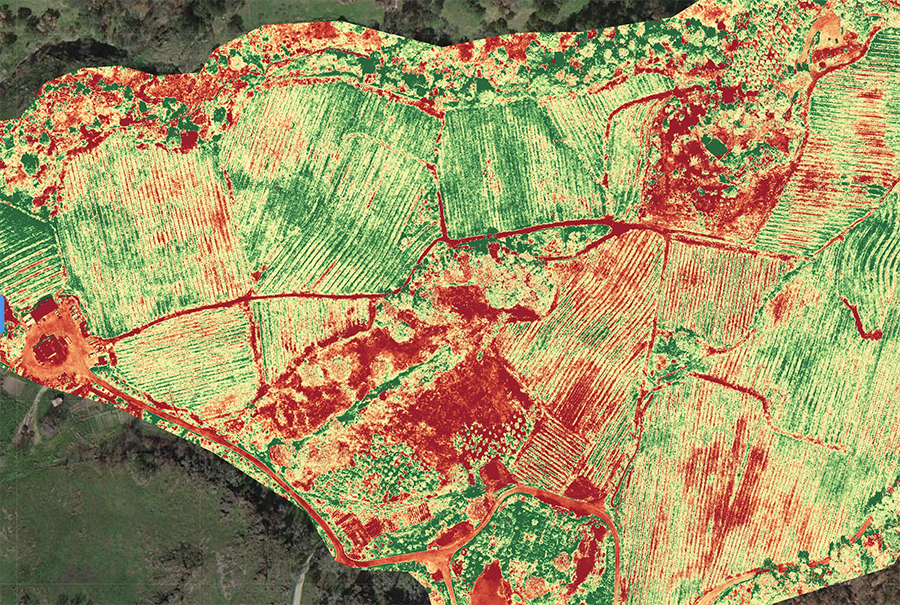
Last year I had the opportunity to study a 200 acre mountain vineyard property throughout the 2017 growing season. We made our first maps in March of 2017, and the final maps on November 1st, 2017. During the course of the season we flew the property 13 full days, each "day" averaging 10 - 14 individual flights. It was a great experience, enough for a book and far too much for a blog, but one of the interesting take-aways to me was simulated NDVI (VARI) and elevation studies.
Normalized Difference Vegetation Index (NDVI) *@wikipedia
Visible Atmospherically Resistant Index (VARI) *@dronedeploy
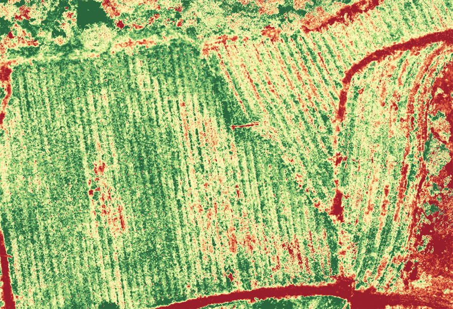
We did it, but I discounted it over and over, for a few very good reasons, it's simulated, I'm not a farmer, and the manager of the vineyard knows the lay of the land...but then I started looking at the files closer to figure out, what it was, if anything, I was looking at, and it started to become obvious to me, layman that I am, that there were patterns in the images. Not earth shattering OMG patterns, just things as a vineyard manager, I think I would want to know. Is plant density greater at different elevations for example, sure you know this as a vineyard manager, but does the imaging support it? If so, are you taking advantage of every opportunity to grow at elevation?
When I look at simulated NDVI for example, I'm not kidding myself into thinking I'm looking at highly scientific data, I can't tell bugs from mold, or over irrigation from over fertilization, I'm a data guy, but I can see really obvious things, green from red, undergrowth, overgrowth, crop density, things that pop out instantly, and might be a useful tool before heading out into the back 40 with a mule full of tools.
Honestly, I don't know, I'm just a guy with a drone and some cool software trying to find out if any of it is useful, but this is some of what we looked at last year in an attempt to answer the question.
This is "Writer's Block" (the saddle shape outlined in red in the center of the image). It's a single block of a much larger vineyard, but we like it because it's "complicated", it has issues, but it's beautiful, in other words, it's like the rest of us. There's a 250' elevation differential between the west and the east edge of this small block, for example. The sparse edge to the right is quite steep, especially where you see the 5 rows of isolated vines which rises to nearly 1250'.
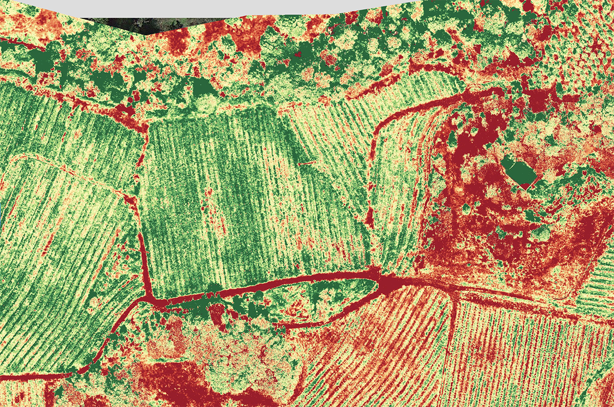
In the center, and throughout the upper right portion of the block, you see more red mixed in with the green. In layman's terms (mine, in other words), green = growth, red = not growth, simple, but it tells us something, simply, some percentage of the block is not producing, why?
In this case, the vineyard manager has worked this vineyard for over 20 years and he knows exactly why the Writer's Block has areas of non-growth, rocks, deep volcanic rocks for example, are the reason for the red in the center of the image, and off to the right as well. He knows grapes will never grow there, but he also knows that's the reason for the flavor of the grapes that do. Like I said, complicated.
But we're not...complicated.
So we can't do anything about the rocks, but there are other issues that there might be a resolution for that would help the grower improve yield, like addressing run off, or increasing irrigation or nutrients in thinning areas.
The point here is, really, that just because it's not true NDVI doesn't mean it's not useful. There are lessons to be learned here, everywhere.
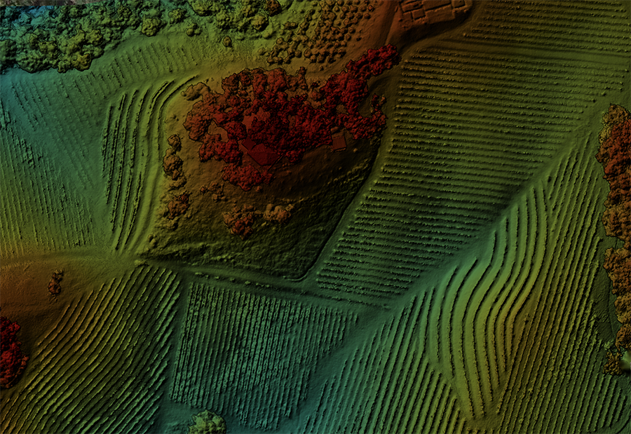
I also started taking a closer look at elevation studies. I knew these vineyard properties inside and out, or so I thought, so when I originally looked at elevation studies, I looked at them much like I looked at simulated NDVI, "ya, so, that's 1000' on that side and 1600' on the other side, so?"
Not, so.
We tend to make things overly complicated, at least I do, perhaps as a need to make them more important than they really are, but we really should be looking for the simplest answers to the most complex questions, no?
Do I see anything at all? Are there areas of color that are growing better than other areas of color, if so, why? Is there anything we can do to move one from one side to the other?
Do I see anything at all? Are there areas of color that are growing better than other areas of color, if so, why? Is there anything we can do to move one from one side to the other?
Again I don't know, I'm not a wine maker or a farmer or a ranch hand...or a crop scientist, I'm just a guy looking at images and wondering if they make a difference.
Additional Info
VARI
NDVI
Category - General
Posted - 06/15/2018 12:45pm Latest Sonoma Drone Promotional Video
Just uploaded the latest Aero Ascensio promotional video, all shot in Northern California and the Sierras in late 2017. This was a collaboration with my son, Maxwell Transue who did the incredible original music. ENJOY!
Category - Light,FAA
Posted - 03/27/2018 11:56am What is Civil Twilight?
What is Civil Twilight?
It's an interesting question, and a more interesting "time" reference.
The Essence:
The limit at which twilight illumination is sufficient, under good weather conditions, for terrestrial objects to be clearly distinguished;
(The rest of this is all trying to quantify what that means, because, you know, we're scientific and litigious, and every once in awhile you have to try to prove what it is, make it more tangible, but it's never the same, so it's hard to prove that it existed, or not, in a particular moment or defined space in time, and it assumes that there also exists an acceptable range of moments and variables which all qualify to fit the definition.
Recreating it is all but impossible, not to mention that it's subjective to less definitive qualifiers, like vision, perception and definition of terms like, good atmospheric conditions and the Sun's upper edge, which in themselves must be qualified and proven before they can be used in additional calculations.
The definition goes on to state:
at the beginning of morning civil twilight, or end of evening civil twilight, the horizon is clearly defined and the brightest stars are visible under good atmospheric conditions
The Scientific part:
Each twilight phase is defined by the solar elevation angle, which is the position of the Sun in relation to the horizon. During civil twilight, the geometric center of the Sun's disk is at most 6 degrees below the horizon. In the morning, this twilight phase ends at sunrise; in the evening it begins at sunset. Sunrise and sunset are the moments when the Sun's upper edge touches the horizon.
The litigious part:
Lawmakers have enshrined the concept of civil twilight. Such statutes typically use a fixed period after sunset or before sunrise (most commonly 20-30 minutes), rather than how many degrees the sun is below the horizon. (since this would be very hard to "prove"). Adding a "range" makes it easier to argue from both sides since not only does there exist an acceptable range, but also acknowledges that there is some flexibility and deviation in the very definition of that range.
In layman's terms:
It seems to me that if it takes the earth 24 hours, or 1440 minutes to rotate 360 degrees, then it's reasonable to assume it takes about 4 minutes to rotate 1 degree (1440/360=4), or, by that math, 24 minutes to rotate 6 degrees (6x4=24), so a general "legal" reference of 20 - 30 minutes (as made above) seems also correct, in a less-definitive sort of way, and while 24 minutes is perhaps more precise, it would rarely, if ever, be exact.
The FAA just refers to it this way
Daylight-only operations, or civil twilight (30 minutes before official sunrise to 30 minutes after official sunset, local time) with appropriate anti-collision lighting.
I like the FAA. Keep it simple. Find out what time the sun rises and sets in the location you're flying, and you can start flying 30 minutes before it rises, and 30 minutes after it sets...in good atmospheric conditions.
Category - General
Posted - 01/19/2018 02:42pm Know the Rules before you Fly!
As drone pilots we often get questioned or involved in discussions about the rules for flying sUAS.
It's really pretty amazing what I hear, not just from the general public but even from other RC and UAS pilots, and it never ceases to amaze me how willing they are to share, and how adamantly they will defend their limited, and somewhat dangerous, lack of knowledge.
In the past month alone I had had people tell me these very frightening (and incorrect) "facts":
- You can fly drones at night, as long as you have lights.
- You can fly FPV (first person view, i.e., using VR goggles) without an observer.
- As long as you can see what the drone sees (through the camera), you can fly it as far away as you want.
- Drones have to fly under 400' and planes have to fly over 500' so drones and planes never share the same airspace. (perhaps the most frightening of them all)
- You can fly 400' over the highest point around you (oh boy...)
- I don't need to be certified if I am just selling the images & video I take
While none of those statements above hold any truth, here are real answers to some of the most common questions:
Who needs to be certified?
Anyone operating any sUAS for hire. Under Part 107, every commercial drone operator needs to be certified by the FAA before they fly over a job site, mine, farm, or any other commercial property. If you are flying your Drone for hire or even for your own in-house commercial use, you must be certified.Do you need to Register Your Aircraft?
Every aircraft weighing between .55 lbs (250 grams) and 55 lbs (25 kg) needs to be registered with the FAA.How far away can you fly?
If you can't see it, it's not legal. You must, or you must have a visual observer in direct communication with you who can maintain a visual line of sight at all times. Any time you fly commercially, you have to keep the UAV within visual line of sight (VLOS). If using First Person View (FPV) or other similar technology, you must also have a visual observer on site to keep an eye on the vehicle without the use of a visual aid (like binoculars).When can you fly?
You are able to fly during daylight or twilight hours (30 minutes before official sunrise to 30 minutes after official sunset, local time) with appropriate anti-collision lighting.What about Weather?
Minimum weather visibility is three miles from your control station.How High can you fly?
The maximum allowable altitude for any drone is 400 feet above ground level (AGL). There are exceptions if your drone remains within 400 feet of a building (or structure) the pilot in command is operating from. The maximum speed is 100 mph (87 knots).Steer Clear of People
You can't fly a small UAS over anyone who is not directly participating in the operation at the time. You also can't fly the aircraft from under a covered structure, nor from inside a covered stationary vehicle.Of course, there are a number of other regulations you must follow to be fully compliant and legal. Know the rules before you fly!
FAA Summary of Part 107 Certification https://www.faa.gov/uas/media/Part_107_Summary.pdf
Here's a good post from our friends at Drone Deploy that summarizes the basics of flying your drone for hire.
Read the full article here:
Category - Wine Country,Wildfires,Insurance
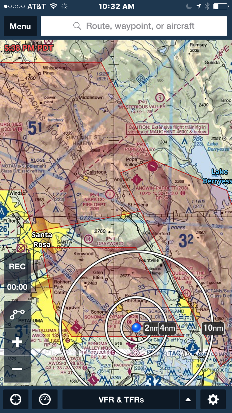
Posted - 10/15/2017 01:16pm California Wild Fires & Local TFRs
Dear friends,
Thank you so much to everyone who was looking out for us...and others this week. I don't mind saying it, it was one long week for everyone here in Wine Country and I don't now how any of us would have made it without all of the continuous support from our friends and families.
The California wildfires have been, and continue to be, devastating to so many of our colleagues, customers, neighbors and friends, and while our office remains untouched by the fires we know that many, many others have not been so fortunate.
We are safe, home, the air is clearing this morning and we're looking forward to rebuilding this beautiful place we call home.
If there is anything we can do to assist in those efforts, please contact me directly at (707) 364-0825.
Temporary Flight Restrictions (TFRs) are still in affect over most of Sonoma and Napa Counties which means no "drones" or any other civilian aircraft are allowed within these TFRs. We will let you know as soon as those TFRs have been lifted and we are able to fly over, assess and photograph affected areas and property.
Please, if you are a recreational drone (sUAS) operator or hobbyist, DO NOT FLY YOUR DRONE. Remember, it is not legal for anyone to fly a drone within Flight Restricted areas. Any drones seen in areas of fire fighting operations will ground all emergency flight crews. This is a serious and life threatening situation. DO NOT FLY! until the FAA lifts the TFRs.
Category - State PArks,Regulations,California
Posted - 08/22/2017 02:08pm Is it legal to fly a drone in a California State Park?
Blaine Transue
That answer is, yes, technically it's "legal", but not necessarily allowed.
That legality is constrained by "posted" notices by any given State Park District. CA state parks are divided into districts and each district can post it's own drone regulations, limitations and restrictions of use on a park by park basis. They are also free to impose non-posted restrictions at their discretion, i.e., tell you to stop for any number of reasons including that it's disruptive to other visitors or frightening the chipmonks.
This is from the official page on the State of CA website regarding the matter. This regulation went into affect in August of 2016 and there don't appear to have been any updates since as this page is still live.
The bottom line here is, it's it's a protected area or preserve, you can't do it, but that's no surprise as you can't take your motorcycle or leaf blower in there either, and you have to stay 2000' above them in an airplane. This isn't a new regulation, and since drones are motorized, their use is prohibited under the same rule.
So, yes, it may be "legal" or "allowed" in certain state parks as far as the state park system is concerned, but it's left up to the local state park district superintendent's to post and impose any additional regulations they feel are necessary within a given park, and these rules and regulations can be based on just about anything from breaking the serenity to public safety.
Keep in mind as well, that some state parks may very well fall under FAA/ATC controlled airspace and in those instances, additional "waivers" will be required from the FAA to conduct the flight at all. Conducting a commercial sUAS flight in controlled airspace is illegal anywhere in the US and doing so risks the license of the operator. When I last checked, and applied for one, the waiting period for waiver approval was at least 90 days, without any guarantee, so you have to plan ahead if you want to film commercially in a state park, especially one under controlled airspace.
August 22nd, 2017
I was asked recently if it was legal to fly a drone in a California State Park, and since it was a very good question, I did some research to see if there was an answer.
That answer is, yes, technically it's "legal", but not necessarily allowed.
That legality is constrained by "posted" notices by any given State Park District. CA state parks are divided into districts and each district can post it's own drone regulations, limitations and restrictions of use on a park by park basis. They are also free to impose non-posted restrictions at their discretion, i.e., tell you to stop for any number of reasons including that it's disruptive to other visitors or frightening the chipmonks.
This is from the official page on the State of CA website regarding the matter. This regulation went into affect in August of 2016 and there don't appear to have been any updates since as this page is still live.
Drones are currently allowed in State Parks, State Beaches, State Historic Parks, State Recreational Areas, and State Vehicular Recreation Areas except where prohibited by a District Superintendent's posted order. Posted orders may prohibit drones for numerous reasons, including: protection of threatened species; threats to cultural and natural resources; high fire danger; public safety; recreational conflicts; impacts upon visitor experience privacy; and park unit classification. Therefore, drone users should always check with their local State Park District for any specific posted orders.
Note the "except where prohibited" part, especially this line "recreational conflicts; impacts upon visitor experience privacy; and park unit classification" It's an important one. The first 2, recreational conflicts and impacts upon visitor experience leave the door pretty far open, although, they might be hard to defend on a day or time when perhaps there were no other visitors. The last one, "park unit classification" applies to the type of park it is.
There are already existing restrictions as to which parks any specific type of motorized vehicle might be used in , for example, and these rules apply to drones as well, one would assume, of any type, flying or not.
Drones in State Wilderness Areas, Natural Preserves, and Cultural Preserves:State Park regulations prohibit the use of motorized equipment (including UASs) within wilderness areas, cultural preserves, and natural preserves (Cal. Code Regs. tit. 14, § 4351.) Therefore, drone users should always check the designation of the park unit before operating a drone.
So, yes, it may be "legal" or "allowed" in certain state parks as far as the state park system is concerned, but it's left up to the local state park district superintendent's to post and impose any additional regulations they feel are necessary within a given park, and these rules and regulations can be based on just about anything from breaking the serenity to public safety.
Additionally, this "allowance" all depends on the capacity in which you are flying your drone.
If you're flying your drone recreationally, i.e., not for any commercial purpose, you can basically contact the district, get the posted (and non-posted) rules, fly your drone (safely) within those rules and regulations (along with the FAA's of course) and be on your way. You might even let them know when and where you're going to do it when you call to get the rules, that way they can field any calls or complaints they might receive.
Here's what the State has to say about recreational drone use in California State Parks.
Recreational Drones:California State Parks recommends that recreational drone users check with their local State Park District before operating a UAS within a State Park. Each park unit may have its own posted orders. Even absent a posted order on drones, it is within the discretion of park staff to contact drone operators when drones threaten visitors, property, wildlife, or privacy. If a drone operator continues to fly in a dangerous or reckless manner, they may be asked to stop flying and remove the drone from park boundaries.
If a state park district doesn't prohibit drone use altogether, and you can actually fly your drone within the posted guidelines and regulations, you should probably consider yourself very lucky. Letting them know when and where just makes them that much more aware of respectful drone operators. After all, most of our flights only last a few minutes and for the most part, aren't that disruptive to the local environment, so give them a heads up, they'll probably actually appreciate it.
You can find Contact Information for the State Park Districts in California here https://www.parks.ca.gov/?page_id=24248
For Commercial operators, I'm afraid the answer is not so simple.
Yes, it's "legal" to commercially operate a drone in California State Parks per the same rule that allows it for recreational hobbyists to do so, but there are even more requirements to meet before you can "legally" fly in a California State Park. In addition to all of the above, commercial operators need to receive special authorization and will require several permits, including one from the CA Film Commission.
Here's how the state website outlines it.
Commercial Drones:The FAA requires commercial drone operators to receive special authorization; either a Section 333 Exemption or a Special Airworthiness Certificate. The FAA defines commercial drone use as, among other things: filming for hire; selling aerial photography or videography; inspections for hire; surveying for hire; or flying to further a business purpose. Operating a drone for commercial purposes within a state park also requires a permit. Commercial Drone users must submit a copy of their FAA authorization to the appropriate State Park District(s). Depending on the proposed use, the District Superintendent may require a Special Event permit, Right of Entry permit, or other approval. Further, commercial photography or filming within State Park also requires a permit from the California Film Commission. (Cal. Code Regs. tit. 14, § 4316.)
Download the Guidelines on filming in CA State Parks https://www.parks.ca.gov/?page_id=24777
Similar rules apply to research and government drone operations, although they don't appear to require the permit from the film commission.
Research Drones:
Drones may prove a valuable tool for scientific research and surveys. Operation of a drone for research purposes requires approval from the FAA. Before operating a drone for research purposes within a state park, please submit a copy of your FAA authorization to the appropriate State Park District(s). California State Parks requires a scientific collection permit (DPR 65) for any scientific research and surveys within a State Park.
Public Agency Drones:
The FAA requires public entities to obtain a Certificate of Waiver or Authorization (COA) to operate public aircraft. Before operating a drone for governmental purposes within a state park, please submit a copy of your COA to the appropriate State Park District(s).
So there's the lowdown on flying your drone in a California State Park. The bottom line is, you need to contact the district to which the park belongs and ask them about their specific drone regulations, and if you're flying commercially, you'll also need FAA approval and permits.
Unmanned Aircraft Systems (drones) in CA State Parks (official State page)
State Park District Offices
CA State Park Film Guidelines

Categories
- All
- Agriculture
- Altitude
- California
- Commercial
- Construction
- Crop Science
- Drone Guns
- FAA
- GCP
- General
- Ground Control Points
- Industrial
- Instruction
- Insurance
- Legal
- Light
- Mapping
- NDVI
- Photogrammetry
- Photography
- Public Concern
- Regulations
- Reviews
- Safety
- Security
- State PArks
- Stitching
- Terrain Mapping
- Vineyards
- Volume Measurement
- Webinars
- Wildfires
- Wine Country
- Nov 2018
- Jun 2018
- Mar 2018
- Jan 2018
- Oct 2017
- Aug 2017
- Jul 2017
- Jun 2017
- May 2017
- Mar 2017
- Feb 2017
- First Passenger Drone Set to launch in July
- A drone software firm has hired two execs from Salesforce and NetSuite
- Drones For Farmers Makes Midwest Startup A Flying Success
- 5 things I learned taking photos with the DJI Phantom 4 Pro
- Drone Captures Wildfire Devastation in Chile
- Caterpillar invests in Airware bringing drone tech to mining and construction enterprises
- FAA: Keep your drone far, far away from the Super Bowl
- Jan 2017
- Man slapped with misdemeanor citation for flying drone near cliffside rescue in Pacifica
- Ningaloo Reef captured from sky in drone-driven health check
- Antonio's One Shot Review, Phontom 4
- What can NDVI drones do for my business? Part 1
- Falcons, drones, data: A winery battles climate change
- senseFly to Host Free ‘Ag Drone Insights’ Webinar
- Modern warfare: Death-dealing drones and ... illegal parking?
- Using a drone during the inauguration could get you fined $1,414
- North Royalton considering banning drones from public areas
- US regulators hammer down on unauthorized drone use
- In Davos, the Police Will Disarm Your Drone in a Heartbeat
- Drone's operator detained for flying near Chinese airplane
- Illegal Drone FPV Transmitters Could Interfere with Air Traffic Control
- Fields of Gold
- Drone delivers medical response