
Category - Agriculture
Posted - 01/26/2017 11:59am What can NDVI drones do for my business? Part 1
By Ian Smith, Sales & Marketing @DroneDeploy
Misconceptions and advice from agriculture industry experts
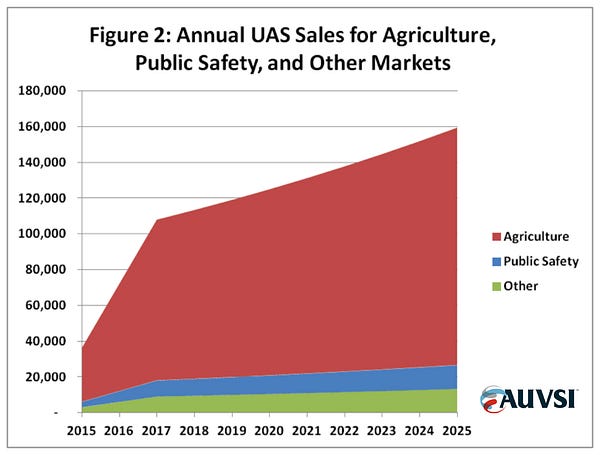
There's a lot of hype about agriculture drones. By AUVSI's own estimates, the U.S. drone industry will be worth $82 billion by 2025, with agriculture generating the lion's share.
For the most part, the hype is warranted — but there's also a decent amount of confusion surrounding ag drones. Just try some quick Googling and you'll start noticing trends; everyone is talking about NIR (near infrared) cameras, vegetation indices, and of course, the ubiquitous NDVI.
We're going to attempt to answer the why, how, and when so that you'll be able to manage your expectations of what NDVI can (and can't) do for you.
Why do I need NDVI, how do I make NDVI maps, and when do I use them?To answer these questions and give insight, we've assembled four industry experts — a veritable pantheon of ag pros.
Let's roll up our sleeves and get our hands dirty as we delve into part one of our two-parter on NDVI, drones, and the agriculture industry.
At DroneDeploy, we've built some popular and effective tools for analysis of various vegetation indices, including NDVI. If you want to get started making NDVI maps today, you can sign up free at DroneDeploy.com
Norm Lamothe
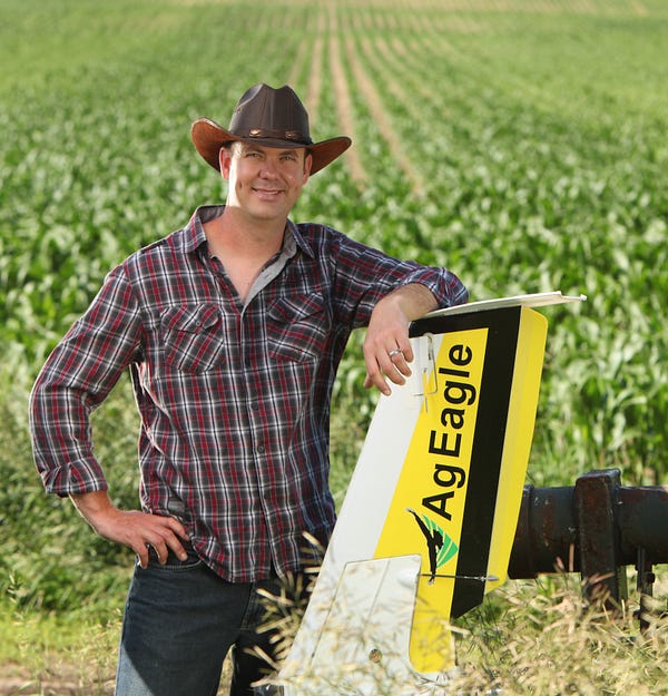
Norm, a manned aircraft pilot, is one of DroneDeploy's most active mappers. He mainly uses his AgEagle. All of Norm's flights are focused on generating actionable aerial imagery. In his business, Deveron UAS, Norm flies drones as a service for growers and farmers — and business is good.
Farming runs in his blood; besides merely looking the part (he's literally Mr. October in the 2016 Faces of Farming calendar), he also walks the walk.
It is extremely important to put your boots on the ground.What is NDVI to you?
NDVI is not a new formula by any means. It's been available to farmers from satellites as an entry-level aerial perspective for a while. It has been very easy to get into and produce. I think that's why it's been so widely used.
What is the value of NDVI?
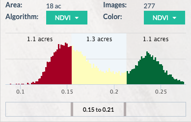
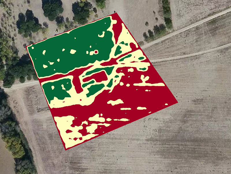
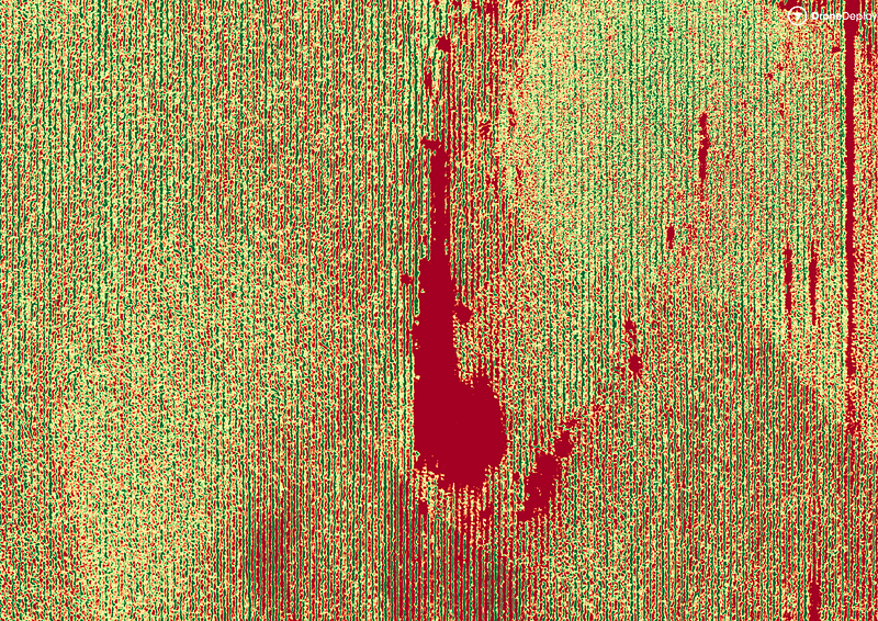
Where we see value is variability. There is always variability in all fields. NDVI highlights this variability and makes it easier for your eyes to see. When you can easily see variability, you can make quicker decisions.
What are some of the challenges with using NDVI?
One of the challenges with using NDVI is that you're not always dealing with absolute values. When lighting conditions and cloud cover change, the camera lens gives you a value of what it sees but doesn't account for the atmospheric change. If you fly over the same fields on different days with the same camera, you should get the same values… but you don't. You'll get the same variability but you won't get the same numbers on the NDVI scale.
Because of this, it is extremely important to put your boots on the ground — every NDVI map should still be ground-truthed.
What's your advice to people who are new to using agriculture drones?
People see a relatively cheap price tag on a drone and think that's all it takes. I come from the aviation industry. Yeah, $50k can get you a Cessna, but that's just the starting point. There are hidden costs.
It's easy not to see the amount of time you spend maintaining the equipment, all the hours uploading and manipulating the images, putting data in specific formats, or the regulatory side of things.
In Canada there are restrictions for operating and permits to obtain. You have to be compliant and safe to run a legitimate business. Be prepared for a lot of work, not just in the fields and at the computer but on the regulatory side as well.
Click here to read Norm's case study, 'Drones — a Soybean Grower's Best Friend'
Chad Colby

Chad Colby is a complex guy: drone evangelist, public speaker, technology early-adopter, professional snowmobiler.
The son of a farmer and the husband of an agronomist, Chad does it all and has fun doing it. His garage of toys puts others to shame. But in Chad's garage, the drones don't classify as toys — they're tools.
The power right now is in understanding your own field. Truly understanding it. Soil type, history — all of it.NDVI has been around for a long time. Drones are a bit newer. Just three years ago we were so focused on putting a drone in the air and getting this NDVI image. It was all that mattered. Stick a modified GoPro on the drone, send it on up, and create the best image ever!
After flying, it took 15-20 hours to process the data. That's what we did back then. These days it's easier. We want to see the inconsistencies in our fields.
What are some misconceptions about NDVI?
I don't care what NIR camera you're using — it takes no account for the soil, the fertility, or other problems in the field. It's just basing the decision off of the vegetation algorithm and imagery from that day. It's not necessarily the holy grail. NDVI maps do not replace an agronomist in the field.
Are yield estimations valuable to a grower?
Not as much as you'd think. Guessing yield is not a critical or unknown component to a farmer. Growers have known how to do that their whole lives. They can take a small section of field, make a quick count, and extrapolate that across the entirety for an accurate estimation.

So what do growers want to know?
They want to know if they have problems on this 160 acre field today or can they move on to the next field and continue their daily routine. The immediacy of the data is what can make a big difference. False NDVI imagery from RGB cameras can even be valuable if they highlight inconsistency — it can be a huge time saver to quickly detect variance and then go to the spot and make a decision.
Any advice for those who are starting a new drone business?
Lots of people are asking how to get into ag with drones. Farmers and growers need to be able to rely on their service provider. You have a huge advantage if you can be at your client's field immediately during, or after a weather event.

- All
- Agriculture
- Altitude
- California
- Commercial
- Construction
- Crop Science
- Drone Guns
- FAA
- GCP
- General
- Ground Control Points
- Industrial
- Instruction
- Insurance
- Legal
- Light
- Mapping
- NDVI
- Photogrammetry
- Photography
- Public Concern
- Regulations
- Reviews
- Safety
- Security
- State PArks
- Stitching
- Terrain Mapping
- Vineyards
- Volume Measurement
- Webinars
- Wildfires
- Wine Country
- Nov 2018
- Jun 2018
- Mar 2018
- Jan 2018
- Oct 2017
- Aug 2017
- Jul 2017
- Jun 2017
- May 2017
- Mar 2017
- Feb 2017
- First Passenger Drone Set to launch in July
- A drone software firm has hired two execs from Salesforce and NetSuite
- Drones For Farmers Makes Midwest Startup A Flying Success
- 5 things I learned taking photos with the DJI Phantom 4 Pro
- Drone Captures Wildfire Devastation in Chile
- Caterpillar invests in Airware bringing drone tech to mining and construction enterprises
- FAA: Keep your drone far, far away from the Super Bowl
- Jan 2017
- Man slapped with misdemeanor citation for flying drone near cliffside rescue in Pacifica
- Ningaloo Reef captured from sky in drone-driven health check
- Antonio's One Shot Review, Phontom 4
- What can NDVI drones do for my business? Part 1
- Falcons, drones, data: A winery battles climate change
- senseFly to Host Free ‘Ag Drone Insights’ Webinar
- Modern warfare: Death-dealing drones and ... illegal parking?
- Using a drone during the inauguration could get you fined $1,414
- North Royalton considering banning drones from public areas
- US regulators hammer down on unauthorized drone use
- In Davos, the Police Will Disarm Your Drone in a Heartbeat
- Drone's operator detained for flying near Chinese airplane
- Illegal Drone FPV Transmitters Could Interfere with Air Traffic Control
- Fields of Gold
- Drone delivers medical response