
Category - Volume Measurement
Posted - 07/24/2017 03:00pm Drone Maps Enable Instant, Accurate Volumetric Analysis
Mining, Construction and Ag Industries Find a Fast, Cost-Effective Alternative to Traditional Volume Measurement
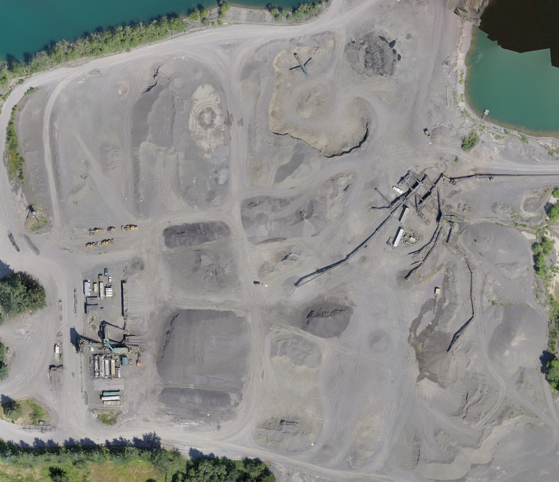
If you are in the construction, mining or agriculture industry, you know that monitoring stockpile volumes is crucial to the success of your work. Whether you are checking to make sure you have enough material to cover a particular area, or providing a financial report of your inventory, accurate and efficient measurement of stockpiles makes all the difference.
Professionals across a variety of industries are finding that drone mapping provides a radically faster, more cost-effective way to calculate both cut and fill volumes, while still maintaining the accuracy of traditional measurement methods. With a built-in volume measurement tool, DroneDeploy's cloud-based software allows them to make instant calculations from any mobile or desktop device.
Mapping Provides a Cost-Effective Alternative
Drone mapping can cover large areas much more quickly than traditional ground methods. Because of this, many industries are seeing dramatic cost savings by switching to drone-based stockpile measurements. Dallas VanZanten of CloudD8ta sees this in his work with Granite Construction (NYSE: GVA), one of the largest civil contractors and construction materials producers in the United States. He uses his drone mapping services to help them monitor their inventory of gravel and recycled asphalt.
Information about stockpile volumes helps Granite Construction's site managers make decisions about whether to extract or process more material to fill their orders, so having up-to-date information is critical. "They don't want to spend too much money to process material that might sit for a while, but they also want enough so that when someone calls they're ready to go," says Dallas. Drone mapping gives Granite Construction timely information about stockpile volumes without the sticker shock of ground-based measurement.
"Drones are safer, faster, and about half the cost as compared to traditional ground-based volumetrics." — Dallas VanZanten of CloudD8ta [click-to-tweet]
Drones Dramatically Reduce Volume Calculation Time
Kelsey Martin of Martin Remote Sensing has found that drone mapping is an efficient way to calculate the volume of stockpiles and pits for his agriculture, mining and construction clients. During a recent project, he surveyed nineteen gravel stockpiles. A ground survey of these stockpiles, using two surveyors, would have taken nearly twelve hours to complete. Kelsey, on the other hand, was on site with his drone for just four hours. After processing the maps in DroneDeploy, he was then able to use the app to quickly calculate the volume of the stockpiles.
"We were able to survey 19 gravel stockpiles in just four hours — a task that would have taken 10-12 hours with two surveyors" — Kelsey Martin of Martin Remote Sensing [click-to-tweet]
Companies Calculate Volumes Without Sacrificing Accuracy
As Kelsey Martin of Martin Remote Sensing has discovered, companies that reap the benefits of efficient drone mapping need not sacrifice accuracy in the process. He recently conducted a field test where he compared the accuracy of volume measurements taken from GPS-surveys of several stockpiles to those taken from a drone map of the same piles. He found that, when following best practices, DroneDeploy's volume measurement tool was accurate within just 0.6%.
"Comparing our [aerial] survey to the "gold standard" yielded a variation of only 0.6%." -Kelsey Martin of Martin Remote Sensing
Read Kelsey Martin's full accuracy report comparing drone-based measurements vs. GPS survey measurements.
Five Tips for Calculating Volume Measurements in DroneDeploy
Drone-based volume calculations can be a highly effective addition to a construction, agriculture or mining company's toolbox. Here are a few tips to help make the most of DroneDeploy's measurement tool when calculating the volume of your stockpile or pit.
- Conduct pre-flight visual inspection of perimeter: Dallas VanZanten of CloudD8ta recommends taking time pre-flight to walk the perimeter of piles and pits. Take note of any indentations or obstacles that might impact your volume calculations and use this ground information to help inform how you select your perimeter points in DroneDeploy's volumetric analysis tool.
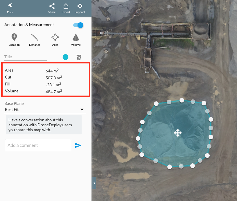
- Select perimeter points carefully: When you are ready to use the volume tool, make sure to select perimeter points that are on flat surfaces outside of the pile or pit. DroneDeploy uses these anchor points to calculate the base plane. Accidentally selecting a point on a pile of rocks, as opposed to on the ground, will affect the accuracy of the volume calculation.
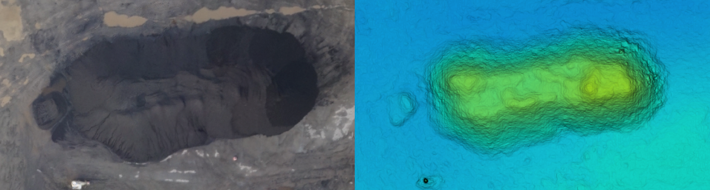
- Use the elevation layer to define perimeters: When using the orthomosaic layer, shadows and homogenous coloring make it difficult to see the toe of a stockpile. To help highlight — and exclude — small standoff piles, use the elevation layer as the base layer of the map instead. Because areas with the same elevation have the same color, it is easy to identify the toe of the pile this way.
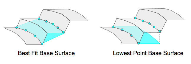
- Choose the right fit: To calculate volume, DroneDeploy compares a "base" surface, defined by the perimeter of your measurement area, to the actual surface of the model. The base surface can either be a "best fit" approximation of the bottom of the pile, or can be a flat plane based on the lowest perimeter point selected. For most stockpile measurements, a "best fit" measurement will be more accurate, but the "lowest point" can be used if the perimeter includes walls or other features around the pile that should not be used to define the elevation of the base plane.
- Generate a report: Install the free PDF Annotations Report app from the DroneDeploy App Market to generate a report of all of the stockpile volumes calculated within your map.

Learn More
Interested in learning more about how drone-based stockpile measurements are changing the agriculture, mining and construction industries? Read Kelsey Martin's full side-by-side analysis of drone-based measurements vs. GPS survey measurements, or check out our support documentation:

- All
- Agriculture
- Altitude
- California
- Commercial
- Construction
- Crop Science
- Drone Guns
- FAA
- GCP
- General
- Ground Control Points
- Industrial
- Instruction
- Insurance
- Legal
- Light
- Mapping
- NDVI
- Photogrammetry
- Photography
- Public Concern
- Regulations
- Reviews
- Safety
- Security
- State PArks
- Stitching
- Terrain Mapping
- Vineyards
- Volume Measurement
- Webinars
- Wildfires
- Wine Country
- Nov 2018
- Jun 2018
- Mar 2018
- Jan 2018
- Oct 2017
- Aug 2017
- Jul 2017
- Jun 2017
- May 2017
- Mar 2017
- Feb 2017
- First Passenger Drone Set to launch in July
- A drone software firm has hired two execs from Salesforce and NetSuite
- Drones For Farmers Makes Midwest Startup A Flying Success
- 5 things I learned taking photos with the DJI Phantom 4 Pro
- Drone Captures Wildfire Devastation in Chile
- Caterpillar invests in Airware bringing drone tech to mining and construction enterprises
- FAA: Keep your drone far, far away from the Super Bowl
- Jan 2017
- Man slapped with misdemeanor citation for flying drone near cliffside rescue in Pacifica
- Ningaloo Reef captured from sky in drone-driven health check
- Antonio's One Shot Review, Phontom 4
- What can NDVI drones do for my business? Part 1
- Falcons, drones, data: A winery battles climate change
- senseFly to Host Free ‘Ag Drone Insights’ Webinar
- Modern warfare: Death-dealing drones and ... illegal parking?
- Using a drone during the inauguration could get you fined $1,414
- North Royalton considering banning drones from public areas
- US regulators hammer down on unauthorized drone use
- In Davos, the Police Will Disarm Your Drone in a Heartbeat
- Drone's operator detained for flying near Chinese airplane
- Illegal Drone FPV Transmitters Could Interfere with Air Traffic Control
- Fields of Gold
- Drone delivers medical response