
Category - Vineyards,NDVI,Crop Science
Posted - 07/24/2017 03:46pm Are Flying Vineyard Drones Creating Better Wine?
http://www.winemag.com/2017/07/20/are-flying-vineyard-drones-creating-better-wine/

Except, just as likely, it could be a drone.
Literally and figuratively, drones in the vineyard are rising as the industry embraces precision viticulture and data-based decision making.
"We have two drones, and they're pretty busy," says Randy Ullom, winemaster at Kendall-Jackson. Its parent company, Jackson Family Wines, has been flying drones over Bennett Valley since 2015 and uses them for marketing, security, surveying and, most importantly, crop analysis.
"They give us more—and more precise—information, which helps us make better wines," says Ullom.
Drones prove useful as wine increasingly embraces sophisticated science, which adds a 21st-century sheen to an age-old craft.
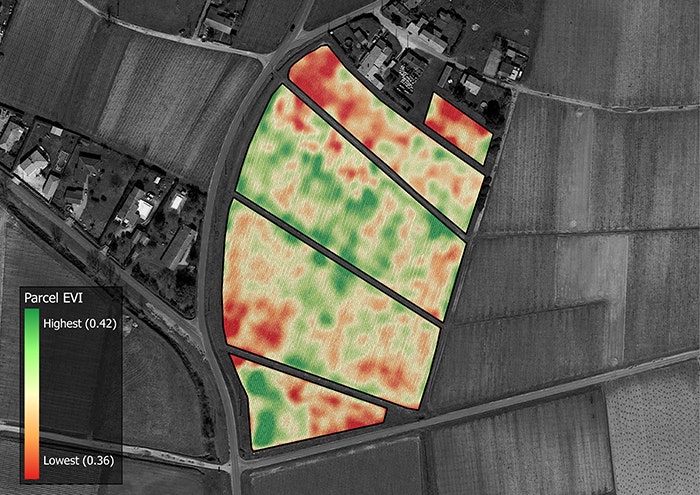
How Drones Map Vineyards
The road from clouds to cork is paved with invisible light.
"Plants that have a high level of photosynthetic activity are healthier than plants that have a low level of photosynthetic activity," says Kevin Gould, founder and CEO of Hawk Aerial, which pilots drones for vineyards.
"The drones take photos using multispectral cameras. They then stitch those images together and then the composite image is processed by a proprietary Enhanced Vegetation Index computer algorithm. This colorizes the image which makes vine vigor visible."
"That alerts the vineyard manager and viticulturist to various levels of health or low health in their vineyard," says Gould, who likens "vigor maps" to compasses. Although they don't tell growers the reasons why vines are weak—be it poor irrigation, inadequate fertilization or pests—they point them in the right direction.
"Water these days is worth more than gold. This technology can help sustain our vineyards to be there for much longer." —Randy Ullom, winemaster at Kendall-Jackson
"It's a lot quicker than driving up and down every row of vines in your vineyard to look at them from the road," says Ullom.
Because GPS is more useful than a compass, data scientists are learning to pinpoint specific problems by measuring even more bands of invisible light. Data analytics companies VineView and SkySquirrel, for instance, have collaborated on drone-based systems that measure water content in leaves and detect stubborn vine diseases like leafroll, flavescence dorée, red blotch and esca, the spread of which can be stopped by identifying and removing infected vines.
"That kind of diagnostic data can help vineyard managers single out problems instead of having to guess at them," says Bryan Soderblom, chief pilot and director of marketing at VineView.
How Drones Improve Efficiency
Drones can help vintners address threats not only to vines, but also to their business. Labor shortages, for example, can be just as toxic as disease.
Yamaha Motor Co.'s RMAX unmanned helicopter targets both. Originally developed in Japan, where it's been serving rice paddies since 1997, their drones began flying in Napa in 2016 and this year in Sonoma. The drones spray vineyards with fungicide to prevent powdery mildew, one of the most common fungal diseases that affect grapes.
 Can Science Save Our Favorite Wines?
"It's much more efficient than hand-spraying," says Brad Anderson, market development manager for Yamaha's Unmanned Systems Division. "Instead of having four guys spray a field for a whole day, they have a full day they can do other activities like canopy maintenance or pruning."

"Because you can't get all the labor you need anymore, you have to prioritize vineyards based on how many times you can pass through them," says Ullom. He says growers can target resources to reduce usage of water, fertilizer and pesticides, which yields financial and environmental benefits as vineyards cope with the effects of climate change.
"Water these days is worth more than gold," he says. "This technology can help sustain our vineyards to be there for much longer."
Can Drones Help Produce Better Wine?
"Wine that's made from diseased grapes has an off-flavor, so disease-free grapes offer wine drinkers a better drinking experience," says Melissa Staid Ph.D., co-founder and CFO of VineView, who says plant vigor also impacts taste. "There's an optimum vigor level associated with quality wine, so the extent to which a grower is proactive about managing vigor will result in a much better quality wine."
Wine quality hinges as much on consistency as vigor.
Gould's experience is the use of drones to survey vineyards leading up to harvest can result in blocks with more consistent quality. "Block uniformity means you're harvesting grapes that are all very similar. If the juice that comes from your grapes is all of the same standard, that results in better bottles of wine, regardless of what price range you're drinking in."
Fifth-generation vintner Ryan Kunde, who is the winemaker and co-founder of DRNK Wines, uses drones to exploit variability. He blends grapes from multiple blocks to achieve his desired flavor profile, a complex mix of vigor and maturity.
"We choose what sites we want to source fruit from, and what portion of the vineyard within those sites we want to make wine from," says Kunde, who produces wines with grapes sourced from the Russian River Valley. "Using imagery from drones helps us zero in on the section of the vineyard we're most interested in."
Is There a Downside To Drones?
As advocates celebrate what drones add to winemaking, skeptics wonder what they might subtract from it: art, instinct, romance and tradition.
Thomas Haun insists that wine lovers have nothing to fear.
"Information from drones is point-in-time information; it doesn't have the history, context and knowledge that experienced vineyard managers and operators have," says Haun, executive vice president of PrecisionHawk, a drone solution provider whose first customers were vineyards. "The folks who operate vineyards have so much passion for what they do. Our intent is to augment that, not replace it."
Category - NDVI,Instruction
Posted - 05/10/2017 06:01pm Multispectral Imaging Drones In Farming Yield Big Benefits
Multispectral imaging sensors on agricultural drones will allow the farmer manage crops and soil more effectively. This multispectral imaging agriculture remote sensing technology use Green, Red, Red-Edge and Near Infrared wavebands to capture both visible and invisible images of crops and vegetation.
The multispectral images integrate with specialized software applications which output the information into meaningful data. This land telemetry, soil and crop data allow the farmer to monitor, plan and manage the farm more effectively saving time and money along with reducing the use of pesticides.
In this article, we look at the basics of multispectral imaging technology, reflectance, wavebands and vegetation indices along with how all this knowledge put together, gives the farmer a full picture of the health of the soil and plants.
We also take a list and give information on the latest multispectral sensors and drones for farming with a few videos along the way.
Multispectral Imaging Agriculture Drones
Benefits Of Multispectral Imaging
Multispectral images are a very effective tool for evaluating soil productivity and analyzing plant health. Viewing the health of soil and crops with the naked eye is very limited and is reactionary. Multispectral sensor technology allows the farmer to see further than the naked eye.
Data from multispectral imaging has the following benefits;
- Identify pests, disease and weeds. Optimize pesticide usage and crop sprays through early detection.
- Provide data on soil fertility and refine fertilization by detecting nutrient deficiencies. Help with land management and whether to take ground in or out of production or rotate crops etc.
- Count plants and determine population or spacing issues. Estimate crop yield.
- Measure irrigation. Control crop irrigation by identifying areas where water stress is suspected. Make land improvements such as install drainage systems and waterways based on multispectral data.
- View damage to crops from farm machinery and make necessary repairs or replace problematic machinery.
- Survey fencing and farm buildings.
- Monitor livestock.
For the full article;

- All
- Agriculture
- Altitude
- California
- Commercial
- Construction
- Crop Science
- Drone Guns
- FAA
- GCP
- General
- Ground Control Points
- Industrial
- Instruction
- Insurance
- Legal
- Light
- Mapping
- NDVI
- Photogrammetry
- Photography
- Public Concern
- Regulations
- Reviews
- Safety
- Security
- State PArks
- Stitching
- Terrain Mapping
- Vineyards
- Volume Measurement
- Webinars
- Wildfires
- Wine Country