
Category - NDVI,Instruction
Posted - 05/10/2017 06:01pm Multispectral Imaging Drones In Farming Yield Big Benefits
Multispectral imaging sensors on agricultural drones will allow the farmer manage crops and soil more effectively. This multispectral imaging agriculture remote sensing technology use Green, Red, Red-Edge and Near Infrared wavebands to capture both visible and invisible images of crops and vegetation.
The multispectral images integrate with specialized software applications which output the information into meaningful data. This land telemetry, soil and crop data allow the farmer to monitor, plan and manage the farm more effectively saving time and money along with reducing the use of pesticides.
In this article, we look at the basics of multispectral imaging technology, reflectance, wavebands and vegetation indices along with how all this knowledge put together, gives the farmer a full picture of the health of the soil and plants.
We also take a list and give information on the latest multispectral sensors and drones for farming with a few videos along the way.
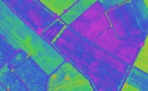
Multispectral Imaging Agriculture Drones
Benefits Of Multispectral Imaging
Multispectral images are a very effective tool for evaluating soil productivity and analyzing plant health. Viewing the health of soil and crops with the naked eye is very limited and is reactionary. Multispectral sensor technology allows the farmer to see further than the naked eye.
Data from multispectral imaging has the following benefits;
- Identify pests, disease and weeds. Optimize pesticide usage and crop sprays through early detection.
- Provide data on soil fertility and refine fertilization by detecting nutrient deficiencies. Help with land management and whether to take ground in or out of production or rotate crops etc.
- Count plants and determine population or spacing issues. Estimate crop yield.
- Measure irrigation. Control crop irrigation by identifying areas where water stress is suspected. Make land improvements such as install drainage systems and waterways based on multispectral data.
- View damage to crops from farm machinery and make necessary repairs or replace problematic machinery.
- Survey fencing and farm buildings.
- Monitor livestock.
For the full article;

- All
- Agriculture
- Altitude
- California
- Commercial
- Construction
- Crop Science
- Drone Guns
- FAA
- GCP
- General
- Ground Control Points
- Industrial
- Instruction
- Insurance
- Legal
- Light
- Mapping
- NDVI
- Photogrammetry
- Photography
- Public Concern
- Regulations
- Reviews
- Safety
- Security
- State PArks
- Stitching
- Terrain Mapping
- Vineyards
- Volume Measurement
- Webinars
- Wildfires
- Wine Country
- Nov 2018
- Jun 2018
- Mar 2018
- Jan 2018
- Oct 2017
- Aug 2017
- Jul 2017
- Jun 2017
- May 2017
- Mar 2017
- Feb 2017
- First Passenger Drone Set to launch in July
- A drone software firm has hired two execs from Salesforce and NetSuite
- Drones For Farmers Makes Midwest Startup A Flying Success
- 5 things I learned taking photos with the DJI Phantom 4 Pro
- Drone Captures Wildfire Devastation in Chile
- Caterpillar invests in Airware bringing drone tech to mining and construction enterprises
- FAA: Keep your drone far, far away from the Super Bowl
- Jan 2017
- Man slapped with misdemeanor citation for flying drone near cliffside rescue in Pacifica
- Ningaloo Reef captured from sky in drone-driven health check
- Antonio's One Shot Review, Phontom 4
- What can NDVI drones do for my business? Part 1
- Falcons, drones, data: A winery battles climate change
- senseFly to Host Free ‘Ag Drone Insights’ Webinar
- Modern warfare: Death-dealing drones and ... illegal parking?
- Using a drone during the inauguration could get you fined $1,414
- North Royalton considering banning drones from public areas
- US regulators hammer down on unauthorized drone use
- In Davos, the Police Will Disarm Your Drone in a Heartbeat
- Drone's operator detained for flying near Chinese airplane
- Illegal Drone FPV Transmitters Could Interfere with Air Traffic Control
- Fields of Gold
- Drone delivers medical response