
Category - NDVI,Instruction
Posted - 05/10/2017 06:01pm Multispectral Imaging Drones In Farming Yield Big Benefits
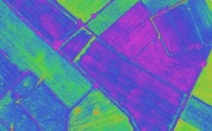
Multispectral imaging sensors on agricultural drones will allow the farmer manage crops and soil more effectively. This multispectral imaging agriculture remote sensing technology use Green, Red, Red-Edge and Near Infrared wavebands to capture both visible and invisible images of crops and vegetation.
The multispectral images integrate with specialized software applications which output the information into meaningful data. This land telemetry, soil and crop data allow the farmer to monitor, plan and manage the farm more effectively saving time and money along with reducing the use of pesticides.
In this article, we look at the basics of multispectral imaging technology, reflectance, wavebands and vegetation indices along with how all this knowledge put together, gives the farmer a full picture of the health of the soil and plants.
We also take a list and give information on the latest multispectral sensors and drones for farming with a few videos along the way.
Multispectral Imaging Agriculture Drones
Benefits Of Multispectral Imaging
Multispectral images are a very effective tool for evaluating soil productivity and analyzing plant health. Viewing the health of soil and crops with the naked eye is very limited and is reactionary. Multispectral sensor technology allows the farmer to see further than the naked eye.
Data from multispectral imaging has the following benefits;
- Identify pests, disease and weeds. Optimize pesticide usage and crop sprays through early detection.
- Provide data on soil fertility and refine fertilization by detecting nutrient deficiencies. Help with land management and whether to take ground in or out of production or rotate crops etc.
- Count plants and determine population or spacing issues. Estimate crop yield.
- Measure irrigation. Control crop irrigation by identifying areas where water stress is suspected. Make land improvements such as install drainage systems and waterways based on multispectral data.
- View damage to crops from farm machinery and make necessary repairs or replace problematic machinery.
- Survey fencing and farm buildings.
- Monitor livestock.
For the full article;
Category - Webinars,Instruction,Agriculture
Posted - 01/19/2017 04:19pm senseFly to Host Free ‘Ag Drone Insights’ Webinar

senseFly, the world’s first choice producer of professional mapping drones, will host a free educational webinar focusing on the different applications of drones in agriculture at 10:00 EST/16:00 CET on Tuesday, January 24.
During this event, experienced operators from two of the ag market’s agronomy leaders—AIRINOV (France) and Deveron UAS (Canada)—will discuss their companies’ drone use, including the opportunities and challenges that adopting this technology brings. Attendees must register in advance here for the one-hour webinar, entitled Ag Drone Insights – Experienced Agronomists Discuss UAV Results, Costs, Workflows and More.
“Across the globe, agronomists, growers and researchers are increasingly using drones to gain deeper insights and to optimise their operations,†said senseFly’s CEO, Jean-Christophe Zufferey. “This webinar will help professionals who have yet to adopt UAV technology to more fully understand how and when drones can help drive their businesses, and those of their clients, forward.â€
Register Here
https://www.sensefly.com/webinars/ag-drone-insights.html
https://www.suasnews.com/2017/01/sensefly-host-free-ag-drone-insights-webinar/

- All
- Agriculture
- Altitude
- California
- Commercial
- Construction
- Crop Science
- Drone Guns
- FAA
- GCP
- General
- Ground Control Points
- Industrial
- Instruction
- Insurance
- Legal
- Light
- Mapping
- NDVI
- Photogrammetry
- Photography
- Public Concern
- Regulations
- Reviews
- Safety
- Security
- State PArks
- Stitching
- Terrain Mapping
- Vineyards
- Volume Measurement
- Webinars
- Wildfires
- Wine Country